Tuesday, February 27, 2024

Davis Mountains State Park

Feb. 20, Tuesday

We've wanted to visit the Davis Mountains area for quite some time. It's one of the few places in Texas with enough elevation to be a bit cooler than the rest of the state when those heat waves hit, and it's also home to a large observatory operated by the University of Texas. This is our first visit to the area, and there's a lot to check out!

During our visit we stayed in the Davis Mountains State Park. The park offers a unique opportunity to experience the natural surroundings and wildlife of this mountainous area both on the trails and on driving tours, enjoy the artistic and rustic handiwork of the CCC's picnic shelters and other structures,  and learn the historic role the area played in the settlement of the area with a tour of nearby Ft. Davis. 

The Davis Mountains campground has a range of campsites to fit different "styles". Some are small, suitable for tents and really short units, others accommodate longer RV's and coaches. Some have only water, others are full service. Maps available on the park's website help sort all that out when making reservations.  There are several sections which makes the camping area feel less crowded than one might think, providing privacy as well as open views of the surrounding landscape.  

The park includes a lodge with restaurant which unfortunately was closed for remodeling and plumbing repairs when we visited. The lodge has an interesting history, having been constructed by the CCC over several years. This article describes the construction phases that resulted in today's very impressive structure. 

The park's other facilities include a small office at the entrance and a small interpretive center located in the campground. Programs are scheduled for some mornings and afternoons but there doesn't seem to be an established schedule so check with office or online. I attended one the program on geology which was very informative, including samples of local stone varieties, geologic history of the development of the landscape we see today, and some photos of examples throughout the park and surrounding area. 

A trail map is available on the park's website, but be aware, it's orientation is completely opposite of the campground map! North is at the top on the trail map and at the bottom on the campground map.)

Wednesday, time to tour the fort!


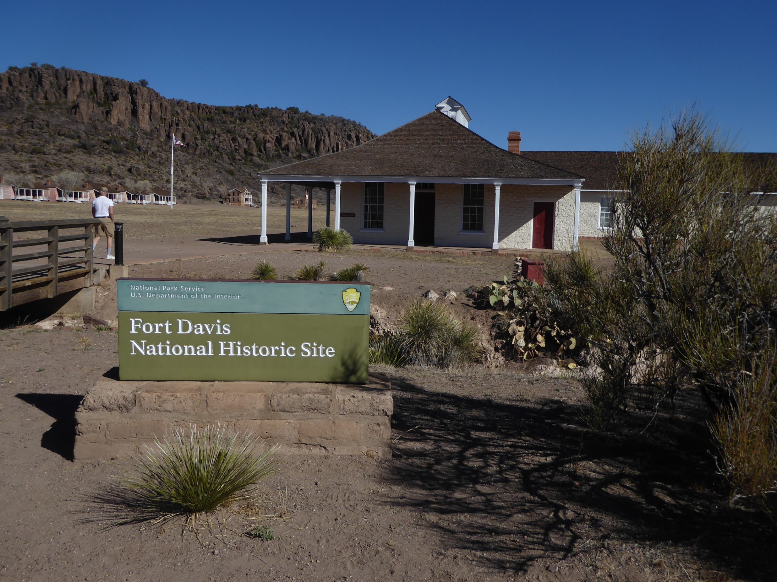
Nearby Fort Davis National Historic Site is probably the first site outside of the park to visit here as it's such an important part of western history and one of the most completely restored. First established in  1854 " By Lt. Col. Washington Seawell with six companies of the 8th U.S. Infantry, in Oct 1854 for protecting travelers on the San Antonio-El Paso Road". The fort was named for the then secretary of war, Jefferson Davis.  Abandoned by federal troops in 1861, it was then activated again in 1867. The fort was retired again in 1891, and in following years had some private usage which helped to maintain some of the structures.  This is a large facility, spread out over 523 acres. A nicely done visitor center (and gift shop) explains the primary purpose and history of the fort and includes information on the Buffalo Soldiers. 


Some of the buildings are completely restored (or almost so) and furnished with period items, such as the infirmary, others are in various states of repair. Many original structures have largely disappeared (adobe brick will do that over time!) and now only the foundation is visible. 

This applies particularly to the stables and other livestock related features that cover a large part of the fort nearest to the main road through town. The full array of the fort structures can be seen from that road (hwy. 17) when on a slight rise. . . or by hiking up one of the hillsides of the box canyon where the fort is located. That's the position from which the panorama above was taken. 


Thursday


The town of Fort Davis, which is immediately adjacent to the actual fort, provides access to groceries and other amenities such as hotels and restaurants. Several businesses are now vacant, or have scaled back services, due in part to the slowdown in traffic during the Covid 19 era. There is a move to renovate several of the hotel properties however, by a group looking to encourage more tourism in the area. 

We did a bit of grocery shopping and then stopped by the county courthouse to admire the grounds and the construction. Texas counties are all rather proud of their historic courthouses, and take steps to keep them well preserved. 

This courthouse was built in 1910 using poured concrete and local stone insets of red rhyolite, a completely different look from other Texas courthouses. It replaced the earlier adobe structure that had fallen into disrepair. 


Thursday

Only a few miles away the Chihuahuan Desert Nature Center and Botanical Gardens is another day trip worth taking. 

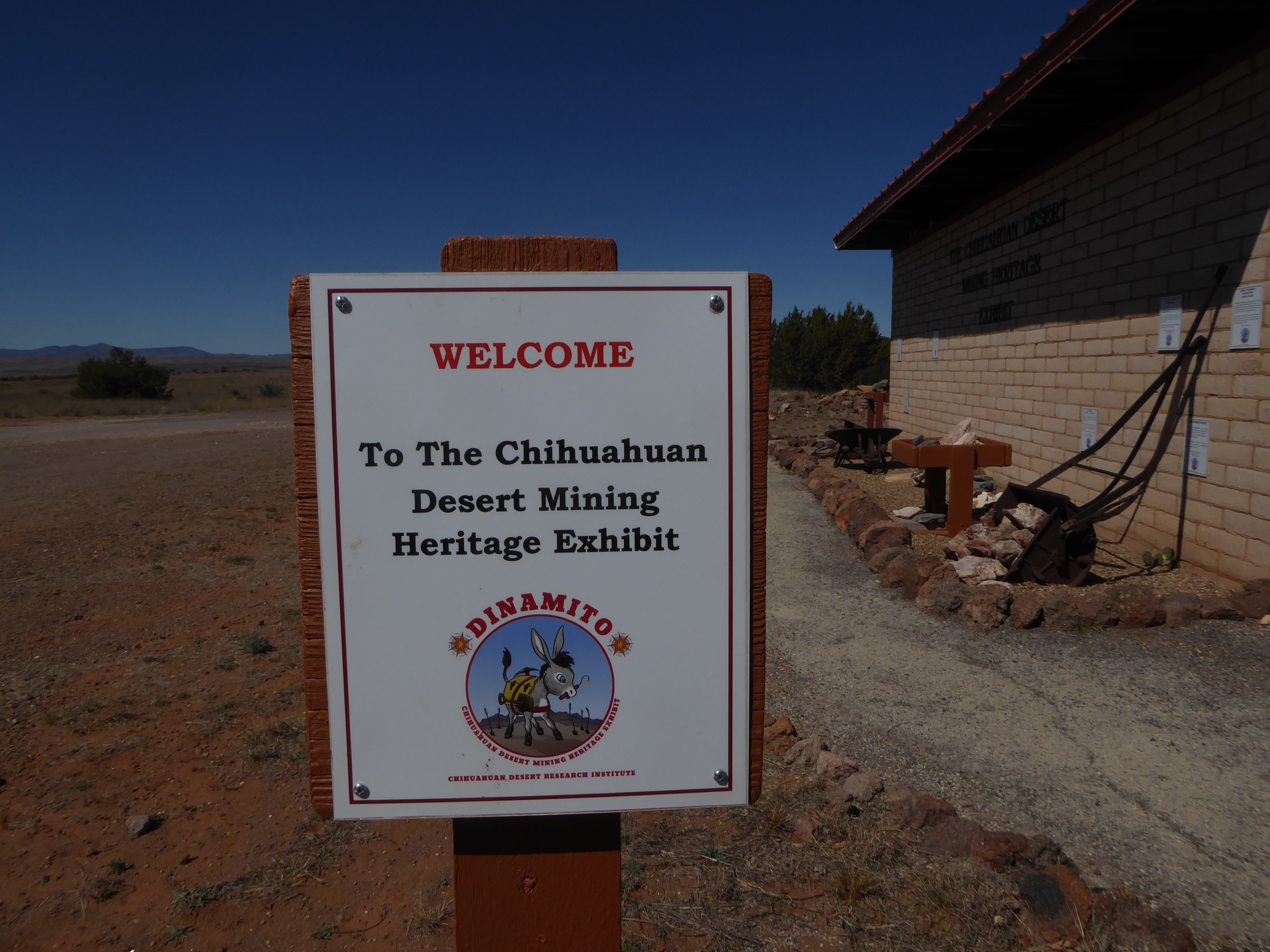
A small but interesting Chihuahuan Desert Mining Heritage Museum display is on one side of the parking area. The display features types of ore, all labeled, mining equipment, and some history of mining in the area. The information signs all feature a little burro named Dynamito, the mascot for the association that sponsors the display. It's a nice recognition of the history of mining in the area and harkens back to the days of individuals trekking across the desert with their burrows laden with tools and grub. 

Inside the visitor center is a gift and book shop, and while we were there they also had a good stock of large potted cactus plants waiting for the upcoming cactus sale to be held in March. The host explained the center's features and provided a trail map, so we set out to explore the gardens and the cactus greenhouse. 


I have to say, seeing what they have inside that greenhouse I'm envious, we won't be here for the plant sale and the greenhouse holds an amazing array of the smaller cacti! Many of the plant specimens along the trail are labeled, but as spring hasn't really arrived here yet they are still dormant. The gardens are a good place to observe wildlife too, and there are benches here and there to sit an watch for birds and other small animals.  

Friday
What an amazing day! Today was McDonald Observatory day on our agenda. Other than seeing a few photos of (one of) the large telescope domes we didn't really have any idea or expectation of what to expect. We had as a goal checking the area out for a future trip with our grandsons and daughter. It's definitely on our list now! 


The visitor center opens at noon and we were a little early,  so spent a little time taking the dogs for a walk. We parked at the far corner of the parking lot as we didn't want them to disturb the official greeting party.... the cute little javelina herd that greeted us when we arrive. There were about 10 of them, including one very small young one. Quite tame, they weren't too upset about vehicles, but in fact trotted over to a couple of cars probably looking for a snack. 

At noon we walked up to the visitor's center, we knew we were on time as the giant sundial that covers most of the entry patio indicated we were 8 minutes early. On the dot of noon the doors were opened and we entered to view the displays about the various telescopes and the observatory, and to buy the very low priced tickets for our selected programs. We selected this time to see the solar telescope viewing program. It was very well done and by the conclusion our heads were filled with some unbelievable information regarding the sun, sunspots, galaxies (our own and others) and other fascinating bits of information. We watched current views of the sun, via the telescope, on a huge screen in almost real time. Due to transmission time there's an 8 minute delay. It was a great program!  


At the conclusion we headed out for the self-guided tour of the telescope domes (the option we had selected) and drove up the hill to first one mountain peak and then the other to see the displays and videos offered there. 
The second of the two telescope we visited was the Hobby Eberly. From the website:" It's made up of 91 hexagonal mirrors that form a reflecting surface measuring 11 by 10 meters. The segments must be aligned exactly to form a perfect reflecting surface for good observations. HET is classified as a 10-meter telescope, making it the third largest optical telescope in the world."

Walking around the areas containing the telescope buildings can be a challenge for some as the elevation is well over 6,000 ft. and some of the roadways and walkways are quite steep. There are some terrific views of the surrounding area due to the elevation, great photo opportunities!

The facility is much larger than we expected, and so are the program offerings. There are guided tours, star watch parties, etc. that require scheduling and tickets purchased ahead of time on their website


More photos in the album

TRIP SUMMARY:

33 DAYS
3583 MILES
304 GALLONS OF DIESEL FUEL, AVG: $4.65 GALLON.  AVG. 11.8 mpg
CAMPING TOTAL: $765    FUEL TOTAL: $1415  AVG. COST PER DAY $67.

We stayed primarily in State and County Parks.  Two nights in private campgrounds and two nights in BLM.  The cost of this trip was very similar to last years which was too the same area's.


Sunday, February 18, 2024

Painted Rock Petroglyph Site and a couple of one night stands

 Painted Rock Petroglyph Site and Campground is part of the Bureau of Land Management system. As a BLM campground is had been free in the past, but as with most of their campgrounds they had started charging a nominal fee several years ago. Now they've gone to a new system, which requires the camping registration and fee be handled online. (You can't even go camping these days without needing the Internet for something!) 

We had registered and paid for our site online the day before our arrival, but just our luck, when we arrived it was occupied! The folks who had decided to settle there had no idea they had to pay to stay there! (note to campers..... read the notices as you enter a campground). They graciously left the site and sought one elsewhere. 

We settled in for the evening and enjoyed the uninterrupted view of the desert. Wide open space and no traffic are rare these days, even in the desert. 

Right after breakfast the next day we walked over to the relatively small rocky outcrop that was situated right in the middle of camp! I'm accustomed to having to trek up fairly challenging trails in some cases to see petroglyphs. These are right in our front yard!  

If you are a fan of petroglyphs, all you can say is WOW! In an article about this site Wikipedia states there are approximately 800 figures in this collection. Even if you aren't, the sheer number and variety of glyphs carved here, over several hundred years, is amazing to think about. Some of the older ones are quite faded due to the continued erosion of the rock, and the ongoing patina forming on the stone. (Patina is the dark brown/black layer that forms on stone that is exposed to the elements for long periods of time. Petroglyphs like these are formed by pecking through that layer, usually with a stone tool. In the photo below the glyphs are layered, with the newer ones on top and much more clearly defined than the older, dim carvings underneath

The importance of this area to several cultures can only be understood if you look at a map and understand that the Gila river, which supports wildlife (aka food for native people), the map on the website linked to above shows the early explorer and pioneer trails, and now highways, cuts right through here. So the proliferation of glyphs may be attributed to the number of travelers passing by, or ????  Interpreting petroglyphs is very subjective, and it's fun to imagine why they are here, but no one can be certain they have the correct interpretation. 

In the afternoon I took the dogs for an off-leash walk out to the riverbed, dry at the time but easy navigating. They enjoyed the opportunity to explore at their leisure with no leashes required as we don't get an opportunity for that kind of exploration very often. 

The following morning we departed for a one night stay in Picacho State Park. This is a regular stop for us when traveling to and from AZ or CA.  The photo below is taken from our site looking toward I-10, a very busy highway, with Newman peak in the distance. The highway is far away, and though we can see the steady stream of traffic we never hear it. At night the lights shine so brightly it looks like a diamond bracelet stretching across the valley.


The park has beautiful scenery, an interesting history, and if you visit a bit later in the year, lots of wildflowers. We were two weeks later last year, so there were more flowers in bloom. Check out that post for details.

For the following day, a short drive, a quick trip to the grocery store, and then one night in Kartchner Caverns State Park. This is another favorite as well as convenient stop on the way home. Good trails for walking, the visitor center is really well done, and the cave tours are too. We spent quite a bit of time here last year. That adventure is here.

Next, a long drive ahead of us, to Rockhound State Park, New Mexico. 

More photos in the album!

Thursday, February 15, 2024

Anza Borrego Desert State Park

We packed up and prepared to leave Lake Cahuilla, but delayed actual departure as long as possible, as our destination was only a short drive away and we knew check-in time was 2 PM. Parks often let campers in a bit early, but apparently that's not the case at Anza Borrego. We arrived about 20 minutes before 2 PM and though we completed the check-in process we were told we'd have to go park by the visitor's center and wait until 2:00. So we did, and of course we toured the visitor center too. 


It's nice, and subtly designed to blend with the landscape. The displays are very informative and really well done. Visitors are greeted by a model of a prehistoric bird that's sure to get everyone's attention!

Once 2:00 rolled around we breezed on through the gate and locate our site. We were situated toward the back of the campground, which is on the lower slopes of a steep canyon. We had a view of the the campgrounds various sections as well as beyond into the valley and the nearby town. 

Steve had a real challenge shoehorning the rig into our site. Be advised when visiting here, the roads and sites are all lined with boulders of various sizes. What looks spacious may not have adequate room for tires when backing in longer rigs. In spite of the challenges we were settled in just in time to watch the Superbowl.... the only TV we watched while we were in the park. 


Our site is in the Palm Canyon campground, one of the most spacious and scenic of the loops, and we are quite near the entrance to the trail that leads up to the palm grove in the canyon. There's a small pond at the base of the trail that is apparently home to several types of frogs. Their happy spring songs really added to the evening atmosphere when we stepped out for the night- time dog walk and a little star gazing. 

The plan while here was to meet up with Steve's brother Dale. He camps here often (usually boondocking) and knows the trails and the sites pretty well. I wanted to try out the trail next to us, up into the canyon, so fit that in early, before Dale arrived. 

The trail is smooth gravel at first then quickly becomes a tumbled, circuitous and sometimes steep path of sand and boulders. The official trail is carefully outlined with smaller stones and pieces of drift wood and palm tree that were damaged during a fire in 2020. The park folks here are pretty serious about hikers not stepping off the official trail so they leave no doubt as to where you should step!  


Water was running freely in the creek, which the trail crossed twice, as far as I went. I had decided to be back in camp by 11 AM, so had to turn around before I made it all the way to the palm grove.  

I arrived back at camp just as Dale was arriving..... perfect timing!

After a short visit we departed for touring some of the sites. First stop, Glorietta Canyon.


There are boondocking sites available on the road it. The park has their regulations for that type of camping posted frequently in all the areas where it is allowed. The trail here is a moderately steep, but very picturesque hike. At the moment, shrubs and wildflowers are thinking about blooming, with a few early achievers popping out here and there, but still offering great photo opportunities. 

Leaving Glorietta we continued our exploration out on the flatland at the base of the hills, suddenly out of the sagebrush here were huge dinosaurs all around us. 

They were rearing, lunging and gnashing their teeth! Well, not exactly, but a good suggestion of doing so. There is a long history of life in this desert, and there's a paleontology research center adjacent to the park, so the dinosaurs fit right in.  

The artist who created the statues and the story of how they came to be has been told in detail by others so I won't try. Here's the best rendition I've found, complete with plenty of photos and videos of the amazing work. The link will take you to several years worth of the authors exploration and study of artist Ricardo Breceda's amazing work. 

Next on the agenda, Font's Point, and a truly amazing example of geologic history. East of the town of Borrego Springs, the viewpoint is reach by traveling through a dusty dry wash.


Parking is in a designated area, and there's no clue of the vision that lies ahead. Walk up the sandy path and when you approach the ridge the view suddenly opens up to reveal a view that rivals the Grand Canyon. It's breathtaking to say the least.  The link above provides how to get there and other relevant information, in addition to plenty of photos.

Dale treated us to dinner at Carlee's cafe (wonderful food!) and we all went back to our camps to rest up for the next day's adventures. 

I the morning we met Dale in town an visited the Anza Borrego Natural History gift shop/bookstore and arboretum. They really have a traffic selection of all kinds of gifts and books and the plant collection in the garden has some specimens labeled so was helpful in identifying things we'd been passing when hiking.  Dale headed home, and we went back to camp planning to relax and start packing up when someone announced big horn sheep on the move so we grabbed our cameras and slowly moved over to the hillside directly opposite our site. Wow, we counted eight at one time, but as they gracefully navigated their way across the rocky and very steep slope they certainly didn't stay in an organized group, so we snapped away to get as many views as we could. There are several shots in the album, sorry so many but they are fascinating to watch!